USGS 3DEP Broad Agency Announcement (BAA)
https://www.usgs.gov/core-science-systems/ngp/3dep
The goal of 3DEP is to complete acquisition of nationwide lidar, IfSAR in Alaska, in 8 years to provide the first ever national baseline of consistent high-resolution elevation data for both bare Earth (DEM) and 3D point clouds collected in a time frame of less than a decade.
The USGS 3D Elevation Program also administers the BAA solicitation and provides detailed information on how to partner with the USGS and other Federal agencies to acquire high-quality 3D Elevation data. It’s a fair and equitable process that allows Federal, State, local, Tribal and even private organizations to propose data acquisition projects. https://www.usgs.gov/core-science-systems/ngp/3dep/broad-agency-announcement-portal?qt-science_support_page_related_con=0#qt-science_support_page_related_con
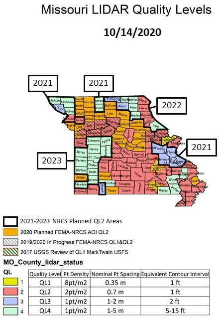
The following status map indicates when and where Quality-Level 2 lidar acquisitions are currently planned in Missouri. Solid red counties are where Quality-Level 2 data is available and or in progress. Quality-Level 2 data will meet or exceed 10cm vertical accuracy RMSEz, a nominal pulse spacing (NPS) of less-than-or-equal to 0.7-meters, a nominal pulse density (NPD, points per square meter) greater-than-or-equal to 2pts/meter squared, and produces a Digital Elevation Model (DEM) cell size of 1-meter.